
1927 BAKER HOUSES
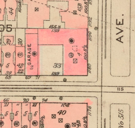
A map showing Lots 31, 33, and 35 (combined as lot 33, city block #1505) at the northwest corner of Park Avenue and 93rd Street, Manhattan, New York City. The conjoined buildings shown (from left clockwise): garage and staff quarters (#69 East 93rd St.); ballroom wing, and north annex (1190 Park Avenue); main house (1180 Park Avenue - aka 75 East 93rd St.) Lot 30 would soon be added to the complex.
- Date
- 1927
- Photographer / author
- G. W. Bromley & Co.
- Archive
- Wikimedia Commons
- Type
- map
- Original size
- 474 × 447 pixels
Public domainsafest
Reason: its US copyright has expired (published before 1931).
Read from: Commons licence category: PD US expired; no CC BY, CC BY-SA, GFDL or deletion tag on the file page; permission field: Public Domain.
Credit line
"1927 BAKER HOUSES" (1927). G. W. Bromley & Co., via Wikimedia Commons. Public domain. https://commons.wikimedia.org/wiki/File:1927_BAKER_HOUSES.pngNeed photos for a whole script? Add Find Any Photo to Claude and ask for this one by its id: 158473.
More like this

Outline and Index Map of Atlas of New York City, Borough of Manhattan, 14th St. to 59th St. NYPL1526301
1920–1922 · Wikimedia Commons

Aerial survey, Manhattan Island, New York City 90680339
1921 · Wikimedia Commons

Sutton Place
1915–1920 · Library of Congress

Manhattan 1920
1920 · Wikimedia Commons

Highest priced apartment house on Fifth Ave.; house to right is Brokaw residence
1913 · Library of Congress

West Side Elevated Highway, 1928 map by W.L. Hamilton
1928-08-26 · Wikimedia Commons

5th Ave. Ap't. House
1910–1915 · Library of Congress

The home of George and Florence Blumenthal, fifty East Seventieth Street, New York, 1920s
1920-01-01 · Wikimedia Commons