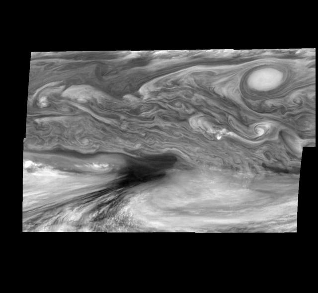
Jupiter Equatorial Region
This photographic mosaic of images from NASA's Galileo spacecraft covers an area of 34,000 kilometers by 22,000 kilometers (about 21,100 by 13,600 miles) in Jupiter's equatorial region. The dark region near the center of the mosaic is an equatorial "hotspot" similar to the site where the Galileo Probe parachuted into Jupiter's atmosphere in December 1995. These features are holes in the bright, reflective, equatorial cloud layer where heat from Jupiter's deep atmosphere can pass through. The circulation patterns observed here along with the composition measurements from the Galileo Probe suggest that dry air may be converging and sinking over these regions, maintaining their cloud-free appearance. The bright oval in the upper right of the mosaic as well as the other smaller bright features are examples of upwelling of moist air and condensation. These images were taken on December 17, 1996, at a range of 1.5 million kilometers (about 930,000 miles) by the Solid State Imaging camera system aboard Galileo. North is at the top. The mosaic covers latitudes 1 to 19 degrees and is centered at longitude 336 degrees west. The smallest resolved features are tens of kilometers in size. http
- Date
- 1998-03-06
- Photographer / author
- NASA/JPL-Caltech
- Collection
- JPL
- Archive
- NASA Image and Video Library
- Type
- photograph
Public domainsafest
Reason: a NASA work: not copyrighted in the United States.
Read from: NASA media usage guidelines: NASA material is not copyrighted in the US unless noted; no third-party credit or mark found.
Credit line
"Jupiter Equatorial Region" (1998-03-06). NASA/JPL/NASA/JPL-Caltech. Public domain. https://images.nasa.gov/details/PIA00604Need photos for a whole script? Add Find Any Photo to Claude and ask for this one by its id: 22011.
More like this
Jupiter Equatorial Region in a Methane Band Time Set 1
1998-03-06 · NASA Image and Video Library

E4 True and False Color Hot Spot Mosaic
1998-03-06 · NASA Image and Video Library
NIMS Views of a Jovian Hot
1998-03-26 · NASA Image and Video Library

Jupiter Equatorial Region in the Near-Infrared Time Set 4
1998-03-06 · NASA Image and Video Library

Jupiter Equatorial Region in the Near-Infrared Time Set 3
1998-03-06 · NASA Image and Video Library

Jupiter Belt-Zone Boundary Methane filter, 732 nm
1998-03-26 · NASA Image and Video Library
Jupiter Long-lived White Ovals in a Methane Time Set 4
1998-03-26 · NASA Image and Video Library

Jupiter Equatorial Region at 889 Nanometers Time Set 2
1998-03-06 · NASA Image and Video Library